
")
")
Our guides have selected three different routes as an introduction to Voltigno Trail Centre. The first ‘Trekking Taffare’ is suited to walkers, Nordic Walkers and trekers. The second ‘Little Gypsy’ is a classic loop in the mountains surrounding the plane and is a half day mountain bike ride. The last ‘Voltignolo Voltigno’ is a gentler mountain bike or walk around the plane.
Trekking ‘Taffare’
The route takes about 3.5 hours is 9.5 KM long with 580 m of climbing and descending. It is intermediate in difficulty. The route includes some of the most interesting trails in Voltigno Trail Centre and passes through mountain gorges, past waterfalls and caves, along streams eventually climbing to the top of Colle della Madona with it’s spectacular views of mountain ranges and the Adriatic.
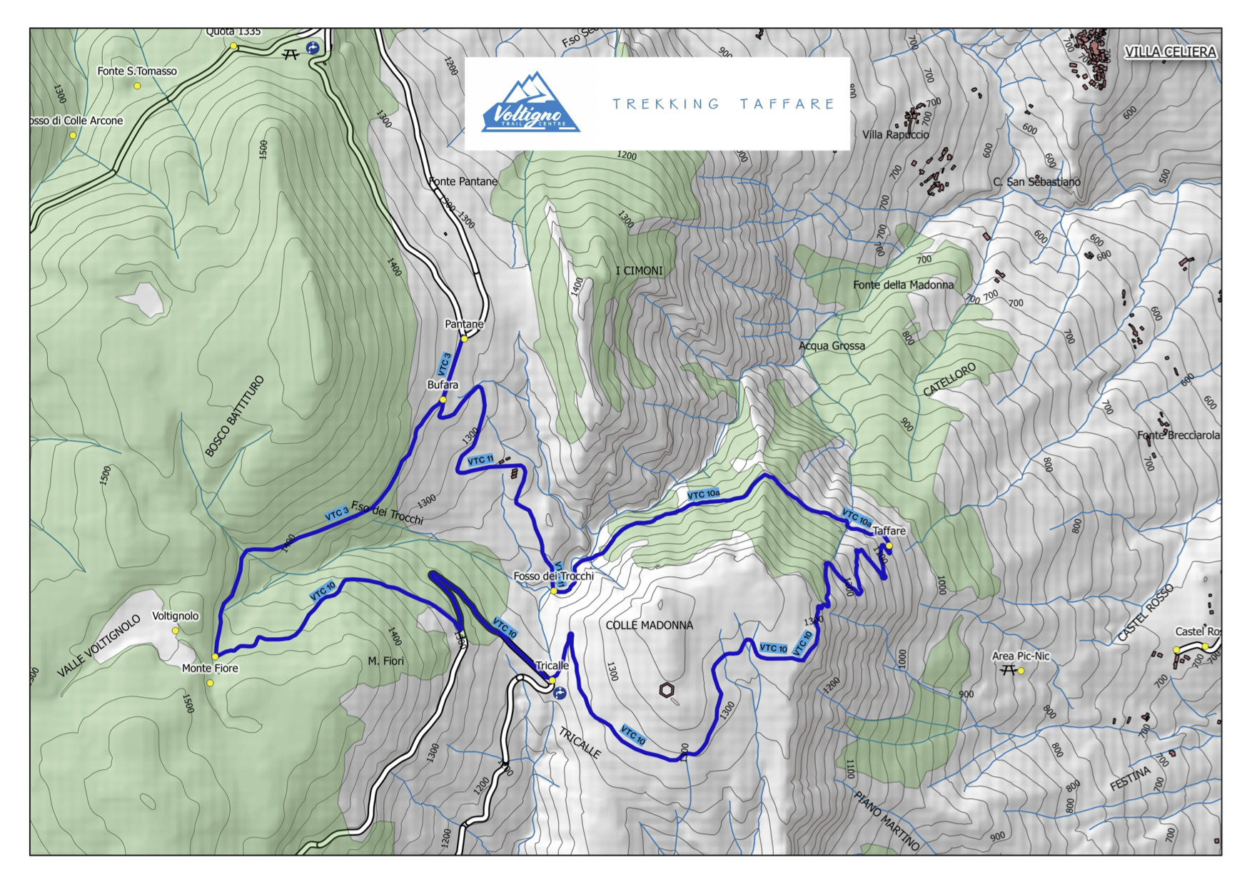
Directions: Pantane (VTC 3) – Bufara (VTC11) – Fosso dei Trocchi (VTC 10a) – Taffare (VTC 10) – Colle Madonna (VTC 10) – Tricalle (VTC 10) – Monte Fiore (VTC 10) – Pantane (VTC 3)
Download GPS Track Taffare.gpx Taffare.kml
If you are travelling from Carpineto del Nora the loop can be accessed from Tricalle.
_______________________________________________________________________________________________________________________________________
‘Little Gypsy’ loop
This route provides everything an ‘all mountain / cross country’ mountain biker would dream of. There are long sections of single track weaving through pine and beech forests, great decants, stiff climbs, interesting technical sections all of which is overlaid with spectacular views.
The trip is 20 KM long climbs and descends 870 M and for an intermediate mountain biker will take approximately 3.5 hours. An additional benefit of this ‘ring’ is that it can be shortened or added to depending on how people feel with out detracting from the experience.
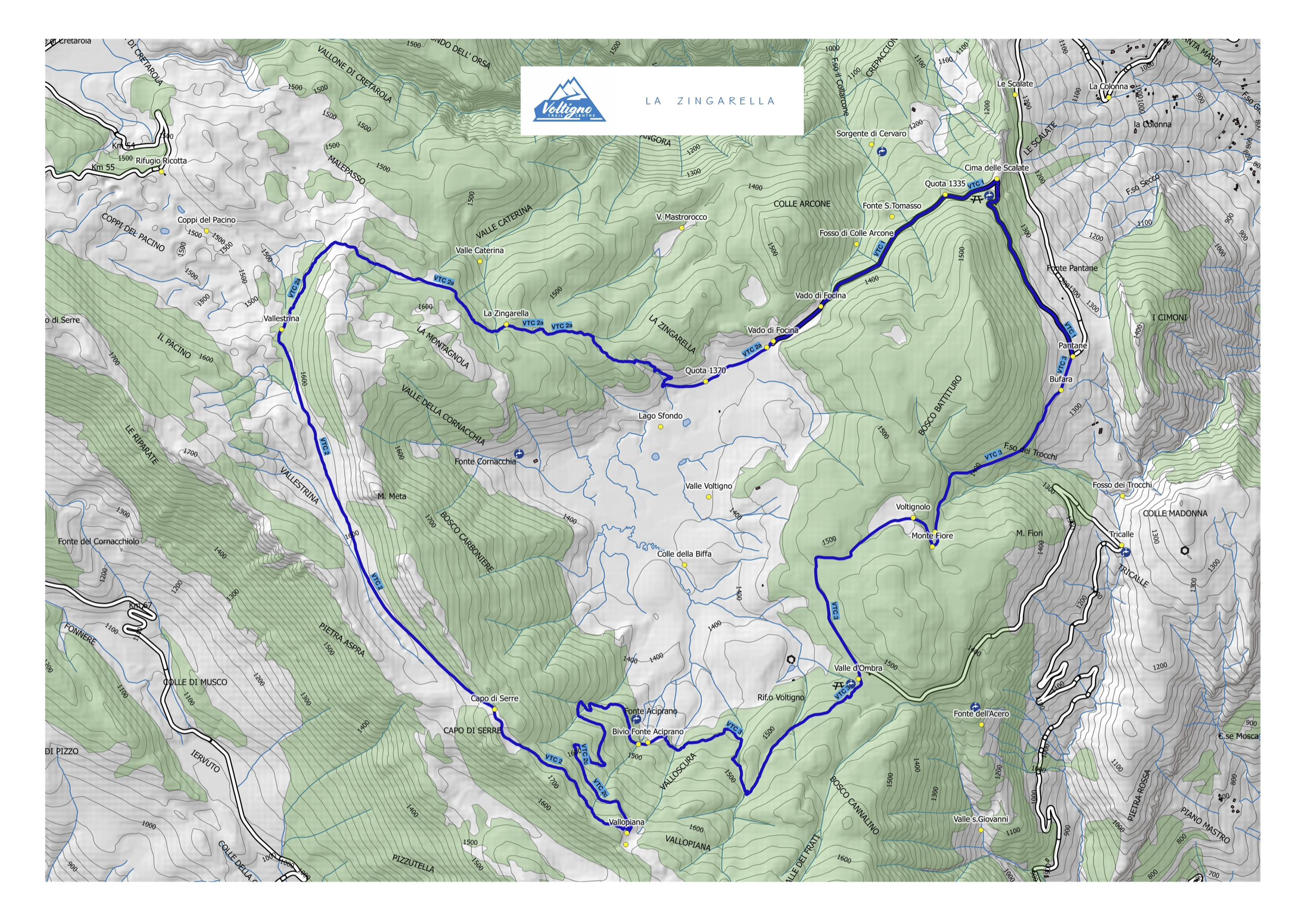
Directions: Pantane (VTC3) – Monte Fiore (VTC 3) – Voltignolo (VTC 3) – Valle d’Ombra (VTC 3) – Bivio Fonte Aceprano (VTC 3) – Vallopiana (VTC 2c) – Capo di Serre (VTC 2) – Vallestrina (VTC2) – La Zingarella (VTC 2a) – Quota 1370 (VTC 2a) – Vado di Focina (VTC 2a) - Quota 1335 (VTC 1) – Cima delle Scalate (VTC 1) – Pantane (VTC 1)
Download GPS Track La Zingarella.gpx La Zingarella.kml
If you are travelling from Offena or Villa Santa Lucia you could join the route via the link trail to Vallopiana, from Castel del Monte you can access the route from Refuggio Ricotta making your way via Coppi del Pacino to Vallestrina and from Carpineto the route can be started at Valle d’Ombra.
____________________________________________________________________________________________________________________________________
‘Voltignolo Voltigno’
The route, which is suitable for either walking or mountain biking, is a great introduction to Voltigno Trail Centre for those who prefer a less demanding way of spending the afternoon. The loop passes through beech forests and the beautiful open planes that are so common in this corner of Abruzzo. It is 9.6 km long and on foot it takes about 3 hours all of which is on easy terrain.
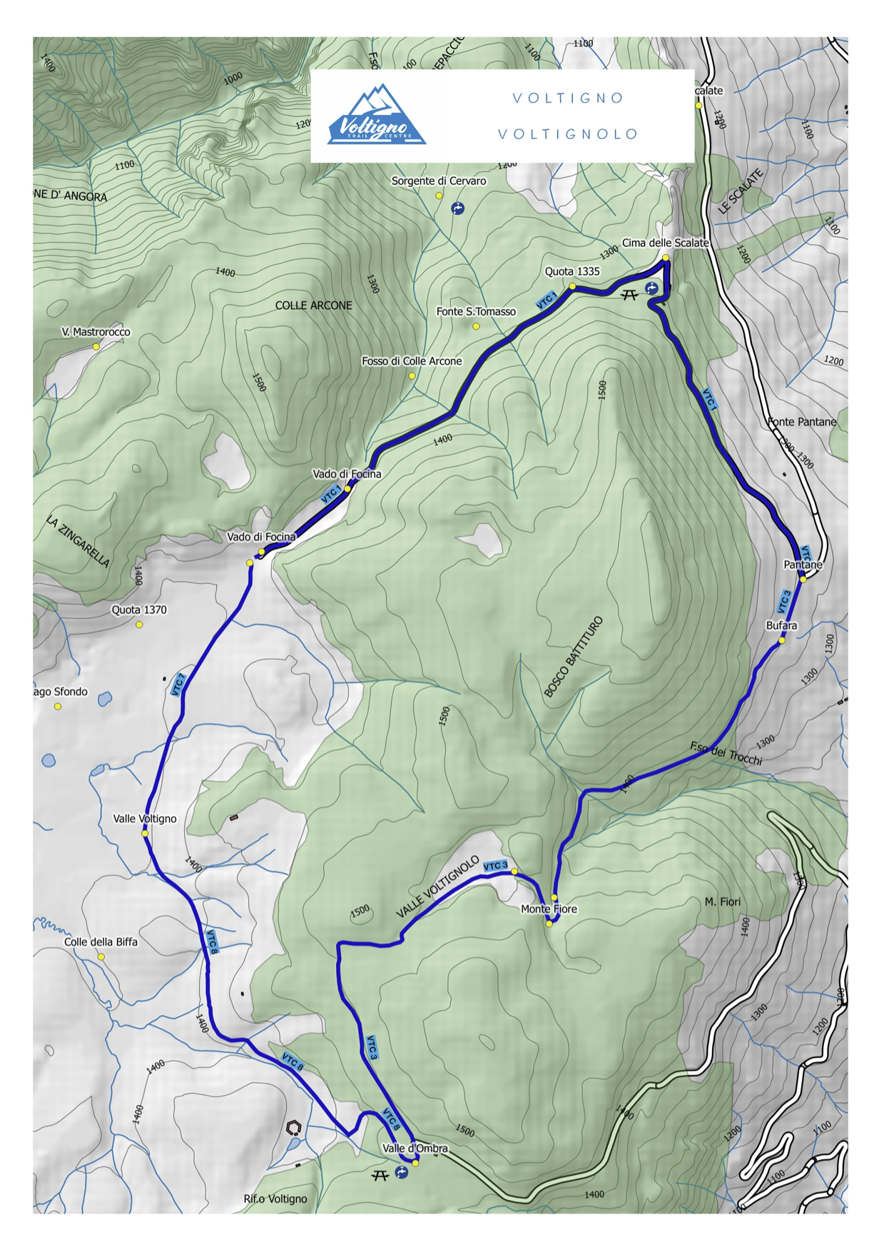
Directions: Pantane (VTC3) – Bufara (VTC 3) – Monte Fiore (VTC 3) – Voltignolo (VTC3) – Valle d’Ombra (VTC 3) – Valle Voltigno (VTC 8) – Vado di Focina (VTC 7) - Quota 1335 (VTC 1) – Cima delle Scalate (VTC 1) – Pantane (VTC 1)
Download GPS Track Voltigno - Voltignolo.gpx Voltigno - Voltignolo.kml
If you are travelling from Carpineto della Nora you can start the loop at Valle d’Ombra
